Dispatch
Breakwater
In the Channel Islands, a crumbling jetty protects a way of life.
April 24, 2024
Try 3 months of unlimited access. Start your FREE TRIAL today. Cancel anytime.
START FREE TRIAL NOW
[.article__paragraph--cap] [.small-caps] In 1847, a decision was made [.small-caps] in Whitehall. It would change the destiny of the small island of Alderney, 150 miles away.[.article__paragraph--cap]
Today, as back then, no one knows about Alderney. From what I can tell, the residents like it that way – mostly. The only reason I know the place is my ancestry. On Dad’s side, my family has been there since at least the 1500s. It’s the northernmost of the Channel Islands – part of the British Isles, but not of the United Kingdom. It falls within the Bailiwick of Guernsey, which, alongside Jersey and the Isle of Man, is one of the United Kingdom’s Crown Dependencies. Despite being British, it lies just ten miles from the French coast, compared to sixty from the English. At just three and a half miles by a mile and a half in size, with a population of only around two thousand, “The Rock” is a true haven – a small-scale place in a large-scale world. While the world suffered from months of lockdowns during the Covid-19 pandemic, life on Alderney continued (mostly) as normal.
Life seems slower here. The shops close on Sundays. And at lunchtime. And at whatever other time takes the shopkeeper’s fancy. Air travel is infrequent, and a sudden fog rising off the Atlantic, or a gremlin in the engine of one of the only two commercial planes that fly there, is enough to keep you stranded for a day or two. There is only one cash machine. It might strike you as the last holdout of a more traditional way of life. But its official websites boast of its appeal to remote workers, its superfast broadband and great transport connections. You might want to get away from the world in Alderney, but the world will find you. Alderney’s a proud part of the large-scale world, and it has been since that fateful decision in 1847.
When the planes are working and the air is clear, the first thing you see when you fly toward Alderney from the north is the breakwater.
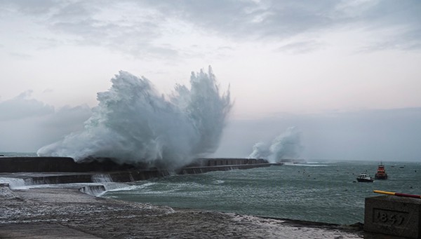
[.imgcaption] Neil Howard, Alderney Breakwater , 2016. [.smalltext] All photographs by Neil Howard. Used by permission. [.smalltext] [.imgcaption]
Today, the breakwater is a half-mile-long wall of stone stretching out into the English Channel. It provides shelter to the island harbor, which in season is full of sailors and yachtsmen. Many of them arrive on Alderney’s shores to test themselves on its tides, which have earned a reputation as some of the most challenging in the world. It also shields Braye, the island’s main beach – a serene white crescent of sand, shimmering like the sharp edge of the sea. Waves will splash over the top of the breakwater most days; in stormy weather, walls of water plow into it, hurling foam dozens of feet into the air. On clear days, though, anglers dot the breakwater’s top, and tourists can be found walking the length of it, peering over the edge into the chop and churn of the ocean below.
On those days, between May and October, there’s another sight you’re likely to see on the breakwater: a large red mobile crane. At the end of its cable hangs a cage, and into the cage go the divers and engineers. “Some of the seaward face can only be viewed from the sea,” Marco Tersigni, one of the infrastructure officers for the States of Guernsey, told me. “Underwater inspection is carried out by a diving contractor during the summer and in the shoulder months. The crane and the cage are used for lowering the divers down to the water. On occasion they can be used to suspend contractors on the seaward face of the breakwater, normally to repoint open joints in the masonry.” I can’t help but think of miners descending pit shafts when picturing these men being lowered down the breakwater’s north side to assess the endless assaults of the waves.
When Whitehall signed off on this edifice in 1847, it was to be the stony backbone of a new “harbor of refuge” on Alderney – a euphemism for “naval base” that fooled precisely no one. Despite its tiny size and population of barely more than a thousand, Alderney’s uneasy proximity to France made it strategically significant. Its natural fortification by violent tides also helped. Over thirty years after the Napoleonic Wars, Anglo-French relations remained tense. Ten miles over the water at Cherbourg, the French were clearly arming themselves. And so, far away from its inhabitants, at the heart of the British military establishment, the decision was made: Alderney would become a “Gibraltar of the Channel” – a grand ambition. A few decades later, a critical French writer would say this was a name “which could only have been born at the bottom of a bottle of sherry.” He would be proven right. The bombastic, bellicose endeavor would, in many ways, be the death of the old Alderney. And yet, nearly two centuries later, its legacy is a lifeline for its modern inhabitants.
[.article__paragraph--cap] [.small-caps] On February 12, 1847, [.small-caps] a ceremony involving cannon fire, flags, prayers, a band, and musketry was held at Grosnez Point, the northern outcrop which would anchor the structure. The foundation stone, a huge chunk of island granite, was dropped thunderously down a cliff. That night, all over the island, people celebrated with fireworks and feasting. Work began in earnest the next day.[.article__paragraph--cap]
The first three years were spent dumping piles of granite into the consuming waters of the Channel to form the base. In places, the sea was up to 150 meters deep. A new inner harbor had to be constructed, along with a railway to access the island quarry and transport stone. Work on the breakwater proper could not commence until 1850.
The original designs for the harbor are truly astounding. The half-mile that remains of it today may seem formidable, but the Admiralty first envisioned a length of nearly two miles curving around the northwest of the bay; this would partner with a shorter breakwater of half a mile or so reaching out from the northeast. Together, they would cast a protective ring of rock around the imagined harbor, resembling a mother’s arms or a crab claw. Here, imagined the men in Whitehall, a mighty fleet could be housed and British merchant ships could seek refuge from French privateers.
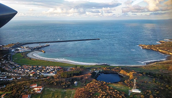
[.imgcaption] Neil Howard, Braye Bay, Alderney , 2018. [.imgcaption]
The breakwater was to be accompanied by mighty fortifications as well. In the decade or so after the breakwater’s construction began, about a dozen military forts were built on the island, along with other battery and barrack buildings. The massive influx of workmen and soldiers required for all this trebled the island’s population from 1,038 in 1841 to 3,333 in 1851; in 1861, it peaked at 4,932.
Plunging stone and brick into the English Channel in order to build a breakwater proved challenging. For one thing, the engineering firm in charge, Jackson and Bean, had no expertise in breakwaters, only canals and railways. One writer described the process some years later:
[.blockquote] The storms of winter tore down the work of the previous summer; the gales of the summer broke down the staging and machinery employed in the construction and swept all into the sea. Still the contractors held on, fighting against all these difficulties with untiring determination, learning lessons for the future by the disasters of the day. [.blockquote]
And yet, against all this, the engineers succeeded – somewhat, at least. The breakwater is still standing. In 2018, it was selected by the Institute of Civil Engineers as one of two hundred structures worldwide that have shaped the world and transformed lives. Yet the original plans were never realized. The second northeast breakwater never even began. The main breakwater, at its peak in 1864, reached 1,471 meters – almost a mile. It had cost, in today’s money, more than 177 million dollars. Yet the structure became, in the worst way, more like a work of art than a civil engineering project – abandoned rather than completed. Within a few years around a third of it, impossible to maintain, had been given up to the sea, bringing the structure to its current length. Ironically, after being intended to protect British ships from the French, the abandoned stretch of breakwater formed an artificial reef that made entry to the harbor hazardous for many vessels, often pushing them to land at Cherbourg instead.
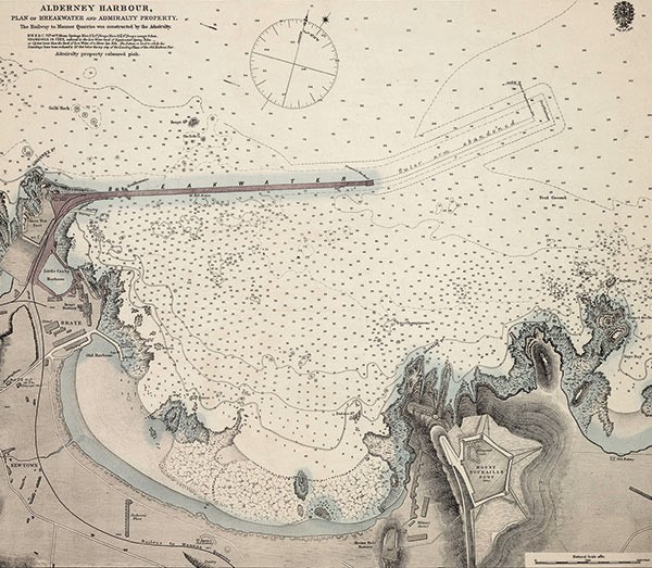
[.imgcaption] Alderney Harbor, plan of breakwater and Admiralty property, 1878. [.smalltext] Image from Wikimedia Commons (public domain). [.smalltext] [.imgcaption]
In the end, the breakwater, the forts, all of it, were for a war that never came to pass. In 1853, France became an ally in Crimea; in 1871, it suffered an unprecedented defeat in the Franco-Prussian War, and was crippled by debt and German occupation. What’s more, developments in artillery meant that, by the time many of Alderney’s forts were finished, they were already redundant – white elephants all. The “Gibraltar of the Channel” it was not.
All of this came at the cost of the island’s centuries-old culture and way of life. Dramatic changes faced a community in which everyone, as English observers condescendingly recorded, was a small landowner and lived “almost exclusively on the produce of their soil.” What else could happen when you quintuple an island’s population in just a few decades and reshape its coastline by artifice? This process was already underway in Alderney prior to the fortifications, but the breakwater accelerated it. A garrison of some four hundred soldiers was stationed there between 1800 and 1815. During this time, as various travel writers record it, the use of the French language in general, along with the island’s native Norman French patois, began to decline. Still, when Queen Victoria visited in 1854 to inspect the building work, banners in the street read “Dieu sauve la Reine.” But this was the swan song of Alderney’s island culture. By 1901, one Channel Island guide could state confidently that “Alderney is the least French of all the Channel Islands. The local patois, which differs considerably from the vernacular of the other islands, is rarely heard nowadays.”
[.article__paragraph--cap] [.small-caps] The locals – the Aurignais, [.small-caps] to give them their proper name – had never held much stock in the government’s grandiose military plans, but even they did not object to the changes these plans brought about. Prior to the breakwater, Alderney’s economic peak seems to have been the late 1700s and early 1800s, when smuggling and privateering abounded, and “the little Alderney privateer reaped a good harvest in a bad way.” But by the mid-1800s, the rise of state navies brought privateering to a close and the island was all the worse for it – its exports being chiefly potatoes and lobster. The economic benefits of a large army garrison and constant construction work were not sniffed at by many. Alderney’s story was one repeated the world over in this era: a central government made a great modernizing decree, giving little thought to how it might upend the traditional culture of the locals, but found that the locals, despite their reservations, were nonetheless happy to acquiesce to the prospect of wealth and comfort.[.article__paragraph--cap]
All this seems so long ago – a different world. The redundant forts have either become lavish residential properties, are used for storage, or have simply been left to the elements for adventurous youngsters to explore. Victorian Whitehall’s choices may seem consigned to being historical curios, a reminder of the buffoonery of government officials. But they are also the visible marks of the many ways life in Alderney was transformed. After the breakwater was built, the mail came twice a week. It opened the doors to a much wider import trade than Alderney had ever experienced before.
And then there is the breakwater – a King Cnut–like structure, testament to madcap military ambition, and somehow essential to the life of this small island. Did anyone in the Admiralty consider how the breakwater would be maintained two hundred years hence? I doubt it – but it is a reality that Alderney must live with.
[.article__paragraph--cap] [.small-caps] Every year, between November and April, [.small-caps] the breakwater is given up to the sea; then, between May and October, the damage must be swiftly assessed and repaired. “Depending on the type, scale, and location of the repair, we normally use concrete either with or without reinforcement,” Marco Tersigni told me. “For repair of underwater joints carried out by the diving contractors we use marine mortars, and normal mortars for above-water joints.” The patchwork nature of the seawall, the changes in the tone and shape of the masonry, are visible as you walk along it, and perhaps even more so from a distance. Since 1987, when the Bailiwick of Guernsey took over ownership of the breakwater from the United Kingdom, more than 31 million dollars have been spent on its upkeep. Much may have changed since 1847, but the Atlantic Ocean has not. Yet the funding of the breakwater – like the funding of much on Alderney – is a continual bone of contention between the island’s own administration and that of the wider Bailiwick. Pouring stone into the sea means pouring money in too.[.article__paragraph--cap]
[.pull-quote] And then there is the breakwater – a King Cnut–like structure, testament to madcap military ambition, and somehow essential to the life of this small island.[.pull-quote]
What would life be like without the breakwater? The ferocious tides mean there is no sufficient natural harbor. Longis Bay, on the island’s southern, French-facing side, once served as a harbor, and was supposedly the site of the island’s earliest settlement. However, it is just as exposed as Braye. Legend has it that the ancient settlement there was wiped out by some kind of natural disaster, interpreted by the locals as divine judgment.
A breakwater is a necessity for a properly functioning harbor on Alderney. And, in 2024, a properly functioning harbor is essential for life on the island. Being a small-scale place in a large-scale world is well and good, but that world can’t be avoided entirely. Without the breakwater, towering waves would dash the Trinity , the island’s twice-weekly supply ship, to pieces on the rocks. The yachtsmen (“boaties,” to the locals) and beachgoers crucial for the island’s tourism industry would cease to find Braye an idyllic holiday destination, and perhaps go elsewhere altogether.
Today, then, the Aurignais have no choice: the breakwater, bequeathed to them by the hubris of some Victorian admirals (and their bottle of sherry) in a decision made far away and long ago, has become indispensable. It must be repaired and repaired again, ad infinitum.